The information contained in this article is not intended as legal advice and may no longer be accurate due to changes in the law. Consult NHMA's legal services or your municipal attorney.
On a hot summer evening several years ago I find myself in a stuffy, poorly ventilated meeting room as part of a zoning board of appeals process. For this application, I represent a property developer before the board. It is getting late in the evening and our matter is finally up on the agenda. I survey the board member’s body language; folks look tired and glazed but they are soldiering on. After preliminaries we get down to business. I am announced as the applicant’s hydrogeologist and a board member looks at me skeptically and asks: “ok, so what exactly is a stratified drift aquifer?” My concerned client looks at me. I need to be clear, concise, factual and not boring or verbose. I clear my throat and begin.
Hydrogeologists and the Planning Board Process
There are many issues that hydrogeologists help municipalities with ranging from helping assess and remediate municipal landfills and waste sites to helping municipal utilities find and permit sources of clean drinking water. These projects are large undertakings that may take many years to complete. Those projects are not what I want to focus on here; this column is devoted to more routine services that hydrogeologists provide daily across New Hampshire for planning board applicants and planning boards/planning departments as part of routine application review process.
Mapping Aquifers
Town Planning Boards and planning staff are generally responsible for making sure aquifer resources are protected and promoting responsible development consistent with master plans and ordinances. Aquifer resources pertain to stratified drift aquifers that can be used for large community supplies. In New Hampshire, these resources are generally located adjacent to major rivers and they are comprised of coarse sand and gravel deposits laid down when glaciers melted and retreated from the area 10,000 years ago. These coarse deposits can yield tremendous amounts of clean drinking water, with some sand and gravel wells yielding flows of over 1000 gallons per minute. Scientists with the United States Geologic Survey (USGS), working with the New Hampshire Department of Environmental Services (NHDES) prepared comprehensive maps of these aquifers in the 1980s and 1990s by compiling drilling data from supply wells, geotechnical borings, and environmental studies. These maps serve as an excellent resource for municipalities looking to develop community supply wells and are commonly consulted by hydrogeologists during early phases of supply well prospecting projects.
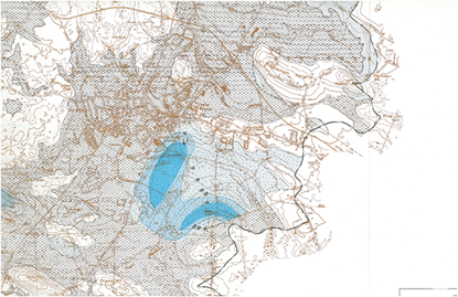
Figure 1: A portion of a USGS/NHDES map showing a small stratified drift aquifer in Stratham/Exeter, New Hampshire.
Aquifer Conservation Districts
Stratified drift aquifers, while prolific are especially fragile because coarse, sandy aquifer material can transmit contaminants like gasoline, oil, and organic contaminants as easily as they can transmit water. Further, because aquifer materials were typically deposited along major river valleys, water sources are commonly located in close proximity to transportation corridors, population centers and industrially zoned land. Town planners manage the competing uses of water supply sources and industrial usage by creating aquifer conservation districts that prohibit certain land uses and require additional responsibilities for applicants looking to develop projects in the districts. These districts are commonly delineated using the regional mapping completed by the USGS and NHDES.
Hydrogeologists are commonly called in by applicants and town planners when boundaries of these districts are called into question. USGS/NHDES aquifer maps were created on a regional, watershed scale and their effort focused on defining areas where aquifers were thickest and where regional water supplies could be most advantageous. Actual aquifer data at the edges of the aquifers is commonly lacking and imprecise; map authors never intended to make these maps to the level of precision required of zoning district maps. Accordingly, site geologic data is sometimes needed to map aquifer boundary in a similar way that wetlands boundaries are defined for low lying property. Applicants wishing to redefine or verify their project’s status relative to aquifer conservation district requirements will commonly hire hydrogeologists to conduct test pits, complete soil borings, and install monitoring tests to evaluate whether the project is truly located in an aquifer. These types of studies are then commonly checked by a “third party” hydrogeologist working for the Town Planner or Planning Board to critically evaluate the aquifer delineation.
If the project is confirmed to be located in an aquifer conservation district, restrictions and limitations are triggered for the applicants. Many towns and municipalities adopted the NHDES Model Ordinance for Groundwater Protection which outline common land use restrictions and limitations aimed at protecting groundwater quality and quantity. Common restrictions and limitations include the following:
Excavation Restrictions:
Generally, sand and gravel extraction is limited to prevent removal within four feet of the seasonal high water table. This restriction keeps a layer of sand and gravel above the water table (technically called an unsaturated zone) at all times. This unsaturated zone provides a filter for stormwater and runoff that may contain salt and other contaminants from reaching the aquifer.
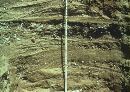
Figure 2: Photograph of stratified drift sand and gravel exposed in a test pit
Waste Water/Stormwater Discharge Impacts:
Community septic systems and infiltration systems installed in aquifers must be sized and located such that the aquifer can adequately assimilate the discharge. There are simple standards that are used by septic system installers to safely install individual residential systems but community or industrial systems may require robust studies and permitting. Hydrogeologists may need to perform specific studies to make sure the proposed discharge will not “mound” the water table potentially resulting in daylighting of the discharge to the ground surface. Further, hydrogeologists commonly complete nitrate loading studies to verify that nitrate (a constituent of domestic wastewater) concentrations will not exceed allowable standards at the property boundary.
Evaluation of Best Management Practices:
Land uses that could potentially impact groundwater quality are termed “potential contaminant sources (PCSs)”. Common PCSs include underground storage tanks, vehicle repair shops, manufacturing facilities that generate hazardous waste, snow dumps, metal working shops and similar land uses. These facilities can be allowed in aquifer protection districts provided that best management practices (BMPs) are implemented to limit the possibility that contaminants will be released into the groundwater. Hydrogeologists working with other environmental professionals and engineers will verify that chemicals and wastes are sited properly (commonly indoors) and that containments and controls are property designed.
Blasting Studies:
Projects that involve blasting for development or to generate aggregate for sale are a specific type of PCS which may require focused study and planning. Hydrogeologists working with blasting experts develop plans to make sure that blasting agents are safely deployed and managed to limit the chances that groundwater quality is impacted. Hydrogeologists may also inventory private bedrock water supply wells in the area of the blasting project to evaluate whether blasting impacts could influence the ability of the private supply well to provide adequate volumes of water.
Implementing/Reviewing Groundwater Monitoring Programs:
It is likely that at the end of planning board deliberations that questions and concerns may remain regarding the impact of a proposed project in an aquifer conservation districts. In these cases, monitoring plans are commonly required which involve installation and sampling of monitoring wells, private supply wells, surface water levels and possibly other data to document the influence the proposed development may have on the aquifer. Hydrogeologists working for the municipality and for the applicant try to strike a balance between collecting needed information to address concerns that arose during the hearing without promoting a research project that is unnecessarily complicated or expensive. Once developed, monitoring data is collected and reports are generated, usually annually, to evaluate the project’s impact. In some cases, municipalities enlist hydrogeologists to help review and interpret this data, and the NHDES is commonly copied on these studies to aid interpretation.
Tips for Retaining Hydrogeologic Experts:
Hydrogeologists are licensed as Professional Geologists in New Hampshire and municipalities are encouraged to seek out licensed hydrogeologist to assist in development negotiations However, there are many specialized types of geologists including geophysicists, remediation specialists, petroleum and research geologists, geotechnical experts, etc. In municipal planning board settings it is best to evaluate whether the professionals hired have experience with municipal processes and whether they have a track record of being able to communicate in public settings. Traits to look for include:
- Knowledge and experience working for both development applicants as well as municipalities; knowing “both sides of the street” can be very helpful in promoting productive communication between applicants and municipal officials and board members;
- Can speak plainly avoiding jargon; geology in general and hydrogeology is filled with arcane, seemingly esoteric words. Many geologists get in this field because of the fascinating nature of earth studies and love to throw around complicated terms to demonstrate their expertise. These experts generally do not fare well in municipal setting where board members are overwhelmingly pragmatic and homeowners/well owners are rightfully emotional and concerned about the risks to their health.
- Along with plain speaking, hydrogeologists need to be able to listen empathically to homeowners and citizens; it can be difficult at times to gently educate homeowners without appearing condescending or pedantic.
- Can work with attorneys; challenging applicant projects almost always involve land use attorneys who represent applicants and/or municipalities. These attorneys will value hydrogeologic experts that can find a common path forward. Most municipalities are not looking to automatically deny projects and most applicants are not looking to ignore safeguards that can safeguard water quality. The trick is working together to find practical ways to move projects forward and efficiently address project concerns.
Considering the ever-increasing environmental challenges faced by New Hampshire municipalities including climate change, drought management, per and polyfluorinated substances (PFAS), as well as the decreasing amount of developable land, the trend is toward an ever more technical planning board approval process. A good hydrogeologist can help take the mystery out of this process and can partner with you to safeguard groundwater quality and bring challenging projects to fruition.
![]()
Dave Maclean, P.G., L.S.P., L.E.P., is a Senior Associate/Senior Hydrogeologist with GeoInsight, Inc. Dave can be reached via email at damaclean@geoinc.com or by phone at 603.314.0820.