The information contained in this article is not intended as legal advice and may no longer be accurate due to changes in the law. Consult NHMA's legal services or your municipal attorney.
New Hampshire’s nine regional planning commissions (RPCs) focus on developing and implementing innovative planning strategies such as regional master plans, environmental plans, data collection and analysis, and other activities. Established by state law (RSA 36:45-58), RPCs are federally designated entities also responsible for providing regional transportation planning services such as developing and updating transportation plans and organizing transportation outreach, projects, and grant submissions. We also serve and advise communities not only by providing requested technical assistance, but also by helping to address various regional planning issues raised by our member communities each year.
In order for us to guide and support planning efforts, we rely heavily on spatial and temporal information that is robust, nuanced, and constantly updated, and on the problem-solving skills to use that information in making decisions. This reliance has made geographic information systems (GIS) an invaluable tool for all of us who support these efforts. RPCs extensively use GIS to develop and deliver effective projects, and we use spatial thinking to transform data into actionable insights and solutions.
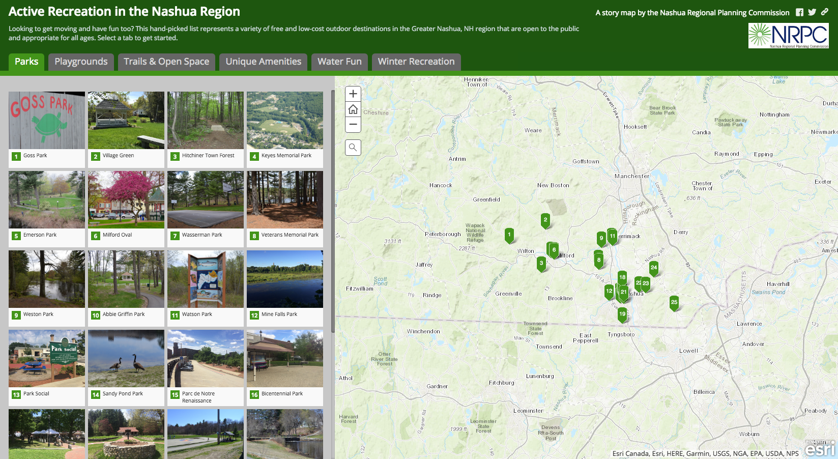
Efforts by the Nashua Regional Planning Commission (NRPC) to help member communities plan for parks and playgrounds provide a good example of how RPCs are integrating GIS technology. NRPC mapped all the parks and playgrounds in the communities and integrated data to perform an in-depth analysis of locations, materials, equipment, and maintenance and to develop case studies of successful playgrounds. NRPC also developed different decision-support tools, including an infographic that helps identifying access to parks and playgrounds in the region and a story map for the general public that shows the location and access points of all recreation areas supplemented by photographs and descriptions.
The Strafford Regional Planning Commission was recently awarded funds for a similar project in which GIS will be used to analyze access to recreation in the Strafford region. Knowing where there is and is not access will help municipal planners and decision makers prioritize funding for projects that will increase the ability of families to be active. We also aim in this project to increase awareness about obesity in children up to age 5 in the Strafford region and to build capacity for local policies and practices to promote recreation.
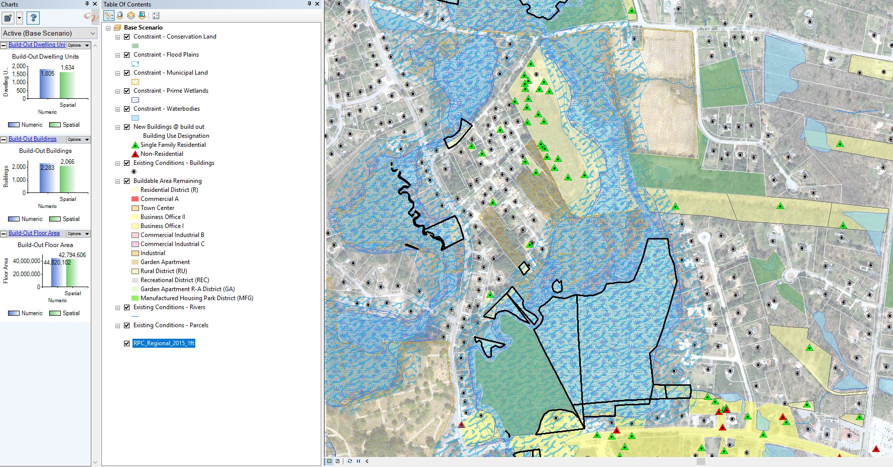
GIS is particularly useful for developing thematic maps to help determine the suitability of areas for conservation, recreation, or development. The Rockingham Planning Commission has been working with several communities on a build-out analysis that integrates GIS to determine current conditions, land use regulations, and growth trends and constraints to create a variety of growth scenarios. Build-out analysis is a planning tool best used for a large study area, such as a community, to help determine inappropriate development, to project maximum residential and commercial development, and to explore the impact of development on the local tax base, traffic, school enrollment, natural and historic resources, and quality of life.
The Rockingham Planning Commission build-out analysis uses spatial data related to such factors as conservation lands, water bodies, wetlands, and steep slopes, and it integrates growth factors that add sensitivity to the analysis. Future build-out scenarios can help community decision makers assess the potential long-term impacts of current land use regulations. For example, if a community were projected to grow by 150 percent in the next 25 years, the number of school-aged children might exceed the capacity of the elementary school or the phosphorus run-off from new homes and yards could affect impaired waterbodies nearby.
Rapid development and growth are among the issues local transportation planners are ready to evaluate with the help of GIS. The Southern New Hampshire Planning Commission and other RPCs have worked with municipalities to tackle one of these issues by implementing bike-sharing systems. The main goal of these efforts is to increase the options for people to travel by bike, but since different communities have different needs, the programs differ somewhat from one community to the next. This work requires planning, organization, and a set of geospatial tools to give planners and designers a snapshot of current programs, track their ridership, and monitor ever-evolving mobility trends. GIS technology can help officials and decision makers prepare local transportation development scenario options for the future or for other communities that want to join the effort. To learn more, see “Bike Share in New Hampshire: Pedal-Powered Progress is Afoot” in the January/February 2019 issue of New Hampshire Town and City (https://www.nhmunicipal.org/TownAndCity/Article/821).
RPCs are constantly helping their communities' integrate and manipulate geospatial data, develop modeling tools, and generate materials such as maps that identify priority action areas, assess natural resource conditions, monitor infrastructure, help prioritize investments, and inform decision makers and the public. Some of the challenges we face are the availability, accuracy, and quality of geospatial data, but an even more challenging task is the integration of data analyses from multiple sources into one coherent planning process. Technological advancements such as cloud technology, real-time data, the Internet of Things, 3D GIS, mobile GIS, and UAVs are expected to grow, and they are also becoming key to smart planning.
The only way for the state’s RPCs to keep up with the ongoing changes in New Hampshire’s communities is to increase our GIS capabilities and develop strategies for better data generation, management and accessibility. One of our long-term goals is to make geospatial data a systematic and preferred source of information for all phases of urban, economic, transportation, and sustainable development projects. But we cannot do this without the active participation and close collaboration of our local organizations and communities, and without raising awareness about the significant potential geospatial information has for planning.
The RPCs will continue using GIS and related visualization techniques to support communities in transferring and applying knowledge in ways that work best for them. We can help provide access to data, maps, and applications, and we can help cities and towns implement GIS projects. Such collaborations involving GIS mean we all have an asset in spatial modeling, decision making, and monitoring that can improve our decisions to take us toward more sustainable and smart communities.
Marcia Moreno-Baez (mmorenobaez@strafford.org) GIS Planner, and Rachel Dewey, Data Analyst, (rdewey@strafford.org) are with Strafford Regional Planning Commission and can be reached at 603.994.3500; Robert Pruyne (rpruyne@rpc-nh.org), GIS Manager, is with the Rockingham Planning Commission and can be reached at 603.658.0520; Sara Siskavich, Assistant Director-GIS/IT Program (saras@nashuarpc.org) can be reached at 424.2240 x21; and Zachary Swick (zswick@snhpc.org), is GIS Analyst with the Southern New Hampshire Planning Commission and can be reach at 603.669.4664.