The Road to Resilience: Five Ways to Advance Climate Action through Regional Transportation Planning
Primary tabs
As New Hampshire emerges from its warmest winter on record[1], it is becoming abundantly clear that the impacts of climate change are already here. Across New Hampshire, communities are experiencing a wide range of impacts – including sea level rise, catastrophic storms, flooding, and impacts to tourism and agriculture. When confronted by a problem of such enormous complexity and scale as climate change, it can be difficult for communities to know where to begin or what might be done.

Inland flooding is the most significant climate risk facing the Southern New Hampshire Planning Commission (SNHPC) region, which covers 14 communities around greater Manchester. The region has experienced devasting floods – including the 2006 Mother’s Day floods and the 2007 Patriots’ Day nor’easter, two 100-year flood events that happened less than a year apart and which resulted in millions of dollars in property damage.
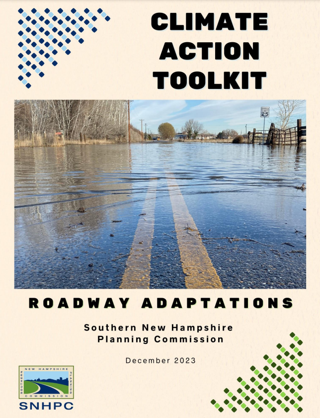
Recognizing that the functionality and reliability of the transportation network is a priority issue for every community, SNHPC is using the topic of roadway adaptation as a strategic entry point for bringing stakeholders together to address pressing climate concerns. Over the last year, SNHPC staff integrated desk research, data analysis, and collaborative input from local, state, and national stakeholders to produce a climate action toolkit focused on roadway adaptation, which is available for free download at https://tinyurl.com/snhpc-adaptation.
SNHPC’s toolkit serves as a practical entry point for anyone interested in tackling climate change through a transportation lens. While the toolkit was developed with the needs of the SNHPC region in mind, it provides a variety of resources and insights for any regional planning commission or municipality concerned about the impacts of inland flooding on transportation networks. This article highlights 5 climate action takeaways emerging from the toolkit.
#1 - Establish a Common Vocabulary
Effective climate action requires bringing multiple perspectives to the table. Some individuals may be well-versed in the data and research around climate change, while others may be less familiar. Likewise, not everyone will have the same proficiency in vocabulary related to transportation planning, ecological concerns, or other local priorities. The SNHPC’s toolkit highlights key vocabulary words throughout the document, which are defined in the text where possible and included in a glossary for reference.
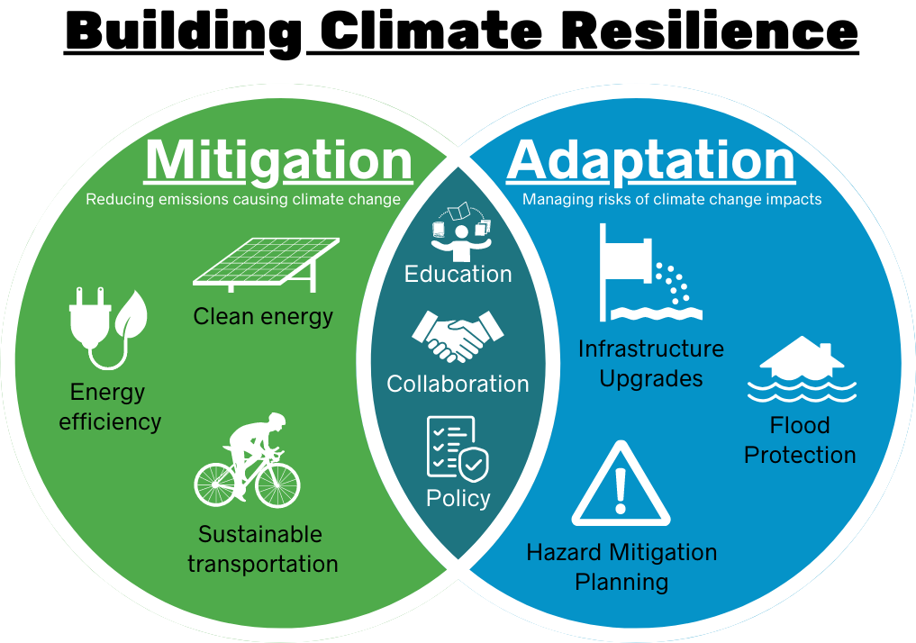
Chapter 1, entitled “Temperature Check: State of the Region” offers a primer on essential climate concepts and explains how warming temperatures are contributing to greater frequency of extreme precipitation events that substantially exceed normal rates. It also offers a vision for a more resilient region, where communities are surviving and thriving in the face of climate change by pursuing both climate adaptation to manage risks associated with climate change, as well as climate mitigation efforts to reduce greenhouse gas emissions. As regional climate planning efforts continue to evolve, this common vision can be used to inform a range of activities related to renewable energy, hazard mitigation, and more.
#2 – Take a Regional Perspective
Flooding caused by a failed culvert can be devasting to nearby property owners, yet it can also have wide ranging impacts that ripple throughout the community. From emergency repairs to travel detours, a road washout can result in fiscal, logistical, and environmental drawbacks for multiple communities. Since climate-related hazards don’t recognize municipal boundaries, it can be helpful to use a regional lens to understand impacts at the network level.
Chapter 2 of SNHPC’s toolkit provides a model for understanding roadway vulnerabilities at a regional scale. It looks at multiple types of vulnerabilities – including stream crossings, steep slopes, and flood-prone areas – and examines these overlapping challenges along each of the major corridors in the region. Notably, it introduces the concept of “aggregate stream crossing vulnerability,” which combines the vulnerability scores of multiple crossings along a single corridor to better understand the risk of failure on key transportation routes that impact multiple municipalities. This type of analysis can complement other transportation planning and project prioritization efforts to maximize regional resilience.

#3 - Provide Multiple Entry Points for Getting Involved
While developing the toolkit, SNHPC staff conducted a detailed scan of resources from federal, state, and local governments, academic leaders, and professional associations. This scan illuminated many different pathways for addressing roadway adaptation at all scales – including site-level concerns (like culvert design), corridor-wide issues (like maintenance practices), and systems change in the way communities and organizations operate day-to-day (such as policies that prioritize climate change concerns.)
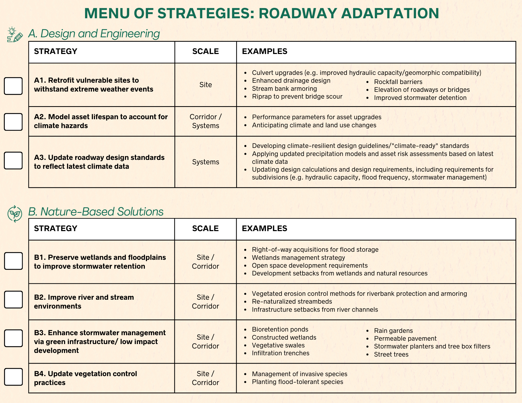
Chapter 3 of the toolkit provides a summary of roadway adaptation approaches organized according to five key themes:
- Design & Engineering
- Nature-based Solutions
- Operations & Maintenance
- Outreach & Collaboration
- Data, Planning & Policy
Each section outlines strategies for implementation, illustrated with project examples and quotes from practitioners. The chapter concludes with a handy checklist that offers an at-a-glance summary of ways to advance roadway adaptation. Ideally, every reader will be able to envision an opportunity to get involved in a way that fits their interests and responds to the unique needs of their local community.
#4 - Compare Data to On-the-Ground Realities
Local expertise is an essential ingredient for vetting vulnerability data and putting roadway adaptation strategies into action. Chapter 4 provides a case study of a corridor in Chester, NH that illuminates how the toolkit’s data and strategies can be used to jumpstart critical conversations with local experts about adaptation priorities.
In May 2023, SNHPC staff facilitated an interactive work session with staff from the Town of Chester to examine flooding concerns on NH-102, an essential east-west corridor in the region. Representatives from planning, police, fire, and highways came together to review vulnerability data and share their on-the-ground insights about local flooding concerns. Collectively, the group was able to successfully narrow down priority sites and issues to address through future adaptation efforts.
The conversation surfaced several key insights that can be helpful for guiding roadway adaptation planning efforts:
- A collaborative corridor analysis can help call attention to potential flood risks coming from nearby sites and communities – whether it’s a red-list bridge across the town line, a privately-owned dam, or a blocked culvert on a local road.
- Symbiotic solutions are needed to address tensions between humans and wildlife, particularly as development pressures increase. Beaver activity is a significant challenge for Chester, as exhibited by a recent costly roadway washout resulting from a beaver dam collapse. The Town is now monitoring impoundments and installing ‘beaver deceivers,’ which are devices that use pipes and fencing to keep ponds level as beavers work on their dams.
- Staffing shortages are impacting climate readiness. Departments that are crucial for managing flooding – like highways, police, and fire – are having difficulty filling positions. Since broader socioeconomic trends will take time to resolve, it’s essential to cultivate greater public awareness and enlist volunteer support where possible to help mitigate flood risks – for example, by clearing culverts in advance of an impending storm.
#5 - Integrate Climate into Planning Efforts at Every Scale
SNHPC is committed to building upon the learnings from the roadway adaptation toolkit to continue advancing climate planning efforts in collaboration with the State of New Hampshire, fellow regional planning commissions, and local communities.
Two key federally funded initiatives are currently driving key climate adaptation and mitigation efforts. US DOT’s PROTECT program has authorized billions of dollars to help make surface transportation more resilient to natural hazards, including climate change, sea level rise, flooding, extreme weather events, and other natural disasters. Meanwhile, the EPA’s Climate Pollution Reduction Grants program (CPRG) is funding nationwide efforts to develop Climate Action Plans to reduce greenhouse gas emissions and slow the pace of climate change.
Under PROTECT, a Resilience Improvement Plan (RIP) is an important next step to advance roadway adaptation projects and access PROTECT discretionary grants. SNHPC is participating in a stakeholder workgroup to help guide NHDOT’s development of a statewide RIP, and we will apply learnings from that process to inform the development of a RIP for the SNHPC region.
Under CPRG, SNHPC is contributing to parallel efforts with both the State of New Hampshire and regional planning commissions in the Greater Boston metro area. We’re engaging with local community members to understand their priorities for forthcoming Climate Action Plans that will reduce emissions and harmful air pollution through equitable, community-driven solutions.
Join the Charge!
There’s no doubt about it – climate change is already here, and we need all hands-on deck to help New Hampshire communities survive and thrive. SNHPC encourages everyone to download the new roadway adaptation toolkit and dig deeper into a topic that matters to you. By working together, we can effectively respond to an evolving climate and identify new and innovative opportunities for human and ecological systems to thrive together.
To learn more about these efforts, be sure to visit the NH Association of RPCs online at www.nharpc.org where you can find your region and take a virtual tour of the RPCs.
[1] Hoplamazian, Mara. “This winter was the warmest on record for New Hampshire.” New Hampshire Public Radio. March 12, 2024.

